What’s New?
- The Railway Lands Area Master Plan is now underway!
- Review the initial information and share what you love about the area today, what challenges might there be over the next 25 years, and ideas or opportunities for the future.
About the Project
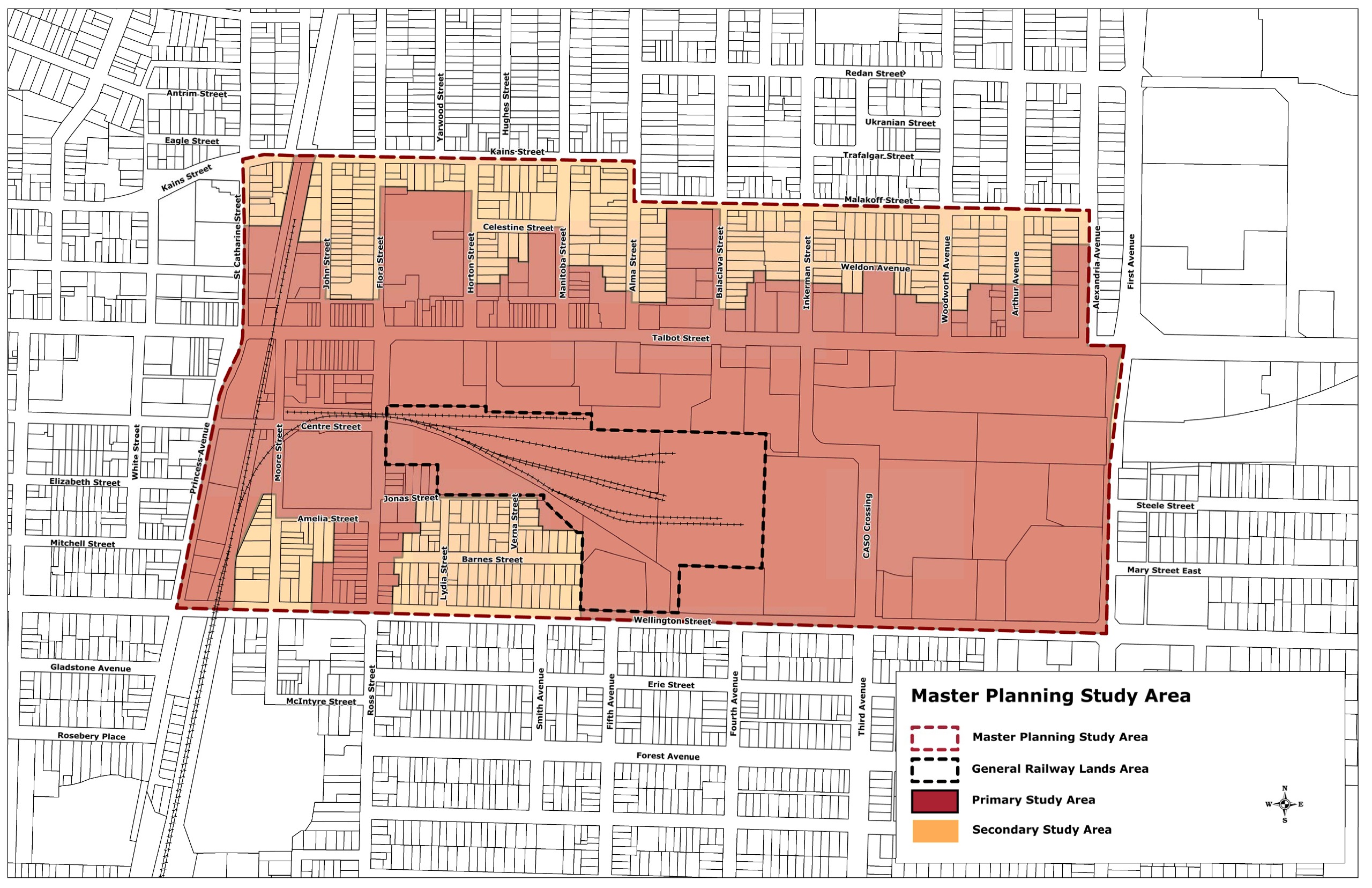
The City of St. Thomas is conducting a land use planning process for a central portion of the Railway City, as shown in the study map below. The intent is to prepare a Preferred Master Plan to help guide future development within the study area over the next 25 years (to 2051).
The Plan will identify areas for development/redevelopment, permitted land uses and built form, transportation and mobility connections, parks and the public realm, public service / community uses, and infrastructure strategies while recognizing and considering significant cultural heritage resources (including the historical significance of the Railway Lands and Downtown St. Thomas Heritage Conservation District) and ensuring appropriate transition of new development to low-rise residential areas.
The Planning Process
The intended approach for this project includes four (4) phases of planning work, each with engagement of landowners, interested parties and the community.
- Phase 1: Context (*Current Phase*)
- Existing conditions, considerations and influencing factors, master plans, situational analysis, guiding principles and goals
- Engagement – What is the project about? How to get involved? What is important about this area? What challenges need to be considered? What opportunities are there?
- Phase 2: Master Plan Concepts
- Develop Concept Plans for land use (residential, commercial, mixed use, etc.), potential building heights and unit density, transportation (road connections, active transportation and trails, transit connectivity, etc.), parks and public spaces
- Engagement – What could the Railway City Central area look like in the future?
- Phase 3: Preferred Plan
- Creating and identifying a Preferred Plan to visualize the future land use of the area, undertake technical review and prepare supporting plans and strategies (servicing and stormwater management, transportation, parks and community infrastructure, cultural heritage, urban design, etc.)
- Engagement – Help shape the future of the area and recommendations for moving forward.
- Phase 4: Official Plan Amendment and Community Planning Permit Bylaw
- Prepare draft and final amendments to the City’s Official Plan and Community Planning Permit Bylaw to implement the Preferred Plan within local planning documents.
- Engagement – formal notices, statutory public meetings, direct input and Council decisions

Expected Results
The Preferred Master Plan for the area would be supported by plans and strategies (transportation, servicing and stormwater infrastructure, parks and community uses, and more). It is expected that implementation will occur through an amendment to the St. Thomas Official Plan that could be in the form of a new Secondary Plan or specific policies for the area. It is also expected that implementation of the plan could occur through adding appropriate locations through an amendment or new Community Planning Permit Bylaw (instead of properties being within the Zoning Bylaw).
Share Your Story: Engagement Opportunities
If you live, work, play, visit, pass through, or know about the Railway City Central area (our Study Area), let us know your story in whatever way feels best by navigating through the tabs below.
Get Involved
Engagement with the community, landowners and interested parties will be an important part of the project process. We will need to hear from you throughout the phase of this planning study. Click on the “Follow” button at the top left of the page to stay connected and receive updates on project information and opportunities to provide feedback as the project proceeds. Stay tuned for future opportunities!
Current Engagement Opportunities
- Contribute to:
- Survey: Getting To Know the Area – Past, Present, Future
- Drop a Pin: Places of Railway City Central Area
- Feedback: DRAFT Guiding Principles & Goals
Future Events/Engagement Opportunities
- Future in-person workshop and online engagement (Phase 2 - stay tuned for timing)
Survey: Getting To Know the Area
Drop a Pin: Places of The Railway City Central Area
Where are we now?
Phase 1: Context
Part of the initial stage of the planning study process is gathering background information, assessing the existing conditions, highlighting what City-wide master plans or strategies may provide directions for the future of the study area, identifying broader factors (housing policy, economic outlooks, community needs, growth forecasts, etc.) and considerations, conducting a situational analysis (strengths/important features, challenges, opportunities), and outlining an overall framework of principles and goals to guide the land use planning of the area.
Please see a summary of the existing conditions, highlights of future plans, considerations, and influencing factors by clicking here.Help Shape the Future of The Railway City Central Area
DRAFT Guiding Principles & Goals
As part of Phase 1 of the project, a set of 5 Principles and Goals has been drafted to help guide the land use planning and future development of the area, creation of master plan concepts and preferred plan for the area (Phase 2 and 3), and to help inform the amendments to the City’s planning documents for the area (Phase 4).
This is an initial DRAFT based on the work to date, common practices for redevelopment areas in existing central locations, and a preliminary assessment of the overall planning direction (including engineering and community infrastructure) for the area. It needs to be reviewed to ensure it is suitable to guide the future of this area. Feedback received from your input about the area, its future and during future phase of the project will help inform the final guiding principles and goals.
We want to hear from you: What do you like? What is missing? What would make these principles stronger?
1. Welcoming Neighbourhoods
- Welcome new homes, residents, shops, services, and jobs in areas that already have roads, sidewalks, and municipal services.
- Bring new life to empty or underused properties.
- Support places where people can live, work, shop, play and gather.
- Make it easier to walk, bike, take transit, or make shorter trips by car.
- Enhance the area as a destination in the central part of the city.
2. Community Character and Heritage
- Care for the buildings, places, and landscapes that help tell our community’s story.
- Respect the features and areas that may have cultural or historic importance.
- Make sure new development fits well in and around heritage areas, local landmarks, and visitor destinations.
3. Responsible Growth
- Make the best use of existing roads, water, wastewater, stormwater, and other municipal services.
- Plan ahead so new growth is practical, coordinated, and cost-effective.
- Use green solutions to help manage stormwater, protect local water, reduce flooding risks, and support a healthier environment.
4. More Choices for Daily Life
- Make everyday needs easier to reach, including shops, services, parks, and community spaces.
- Encourage a wide range of housing options for different ages, incomes, and household needs.
- Help new development fit comfortably near existing homes, businesses and neighbourhoods.
- Provide new residents uses and design that supports the vibrancy of Talbot Street.
- Design places that are safer, more resilient, and better for the environment.
5. Better Public Spaces and Connections
- Improve streets, sidewalks, parks, and open spaces so they are safe, comfortable, and welcoming.
- Create stronger connections between the Railway Lands, Talbot Street/downtown, and nearby neighbourhoods.
- Make walking, cycling, and other active transportation options easier for people of all ages and abilities.
- Add trees, landscaping, shade, and green features where they can make outdoor spaces more pleasant.
- Design streets and buildings to support comfort, accessibility, safety, and community well-being.


